
 Spark Energy Minerals
Vancouver, British Columbia--(Newsfile Corp. - September 30, 2026) - Spark Energy Minerals Inc. (CSE: SPRK) (OTC Pink: SPARF) (FSE: 8PC) ("Spark" or the "Company") is nearing completion of an initial prospecting phase at its Solonópole Project in Ceará, north-eastern Brazil, and is awaiting sample results from SGS. For Spark, the opportunity is to look beyond the district's historic workings and test what its 15,691-hectare position could hold. The pending results will help guide that search for metals used in electronics, aerospace and batteries.
A 91,900-Hectare Flagship, a Separate Opportunity in Ceará
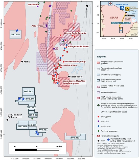
Solonópole comprises eight exploration permits and one application covering 15,691.24 hectares, with most of the ground west of the documented pegmatite corridor (Figure 2; Table A1). It is a separate property in Spark's Brazilian portfolio, alongside the approximately 91,900-hectare flagship Arapaima Project in Minas Gerais' Lithium Valley.
Paved highways connect the Project towns to Fortaleza, 275 km by road to the north-east, with its international airport. The Port of Pecém is about 320 km by road.
"What draws us to Solonópole is the combination of mining history and a geological question we can test on the ground," said Dr. Fernando Tallarico, Chief Executive Officer of Spark Energy Minerals Inc. "This was not just a lithium district: miners also recovered minerals containing tantalum and beryllium. The Geological Survey of Brazil's work helps us understand the host rocks and rare-metal enrichment, and gives our team a reason to look west of the old workings. Arapaima remains our principal project, with its gallium and rare earth discoveries. Solonópole is a distinct opportunity to explore for tantalum, beryllium and lithium within our Brazilian critical-minerals portfolio."
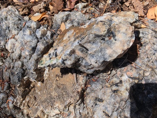
Historic Mining, Modern Demand: Tantalum, Beryllium and Lithium
Solonópole's historical workings produced minerals containing tantalum, beryllium and lithium, metals now used in electronics, aerospace and batteries. All three are on the 2025 United States List of Critical Minerals. This mining history, together with regional geological evidence, gives Spark a reason to explore beyond the old workings, which lie outside its permits.
Looking West of the Old Workings for Rare-Metal Pegmatites
The Geological Survey of Brazil's ("SGB") 2026 study describes lithium-cesium-tantalum ("LCT") pegmatites: coarse-grained rocks enriched in rare metals as their parent magma evolved. The study reports that SGB visited 68 lithium-bearing pegmatites and that its regional geochemical index detected 65 of them. Spark's exploration question is whether the favourable host rocks and regional geochemical trends extend to mineralized pegmatites on its permits.
Most of Spark's ground lies west of the documented pegmatite corridor, on the Acopiara Complex and adjoining granite belts; this description does not apply to title 800.952/2022. SGB places most of the district's documented lithium bodies in that complex or along its contacts with the Banabuiú granites. Its mineral studies also identify cesium and rubidium enrichment, indicators that help guide exploration for rare-metal pegmatites.
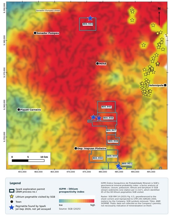
SGB's regional stream-sediment index shows a belt of high values extending across much of Spark's ground west of the known corridor, rather than the entire land package (Figure 3). This is a guide for follow-up, not a map of pegmatites: the public samples were not collected on Spark's permits. Mapping and sampling on the ground are needed to test the interpretation.
From Geological Clues to Field Evidence; SGS Results Pending
Spark is finalizing its initial prospecting phase and awaiting sample results from SGS. The broader work program includes mapping pegmatite dykes and host rocks, ground-checking old workings with former miners, and sampling stream sediments and panned concentrates across the permit drainages. Any pegmatites identified would be mapped and sampled across their widths, with rock-chip and mica samples tested for tantalum, niobium, beryllium, tin, lithium, cesium and rubidium. The program also includes interpretation of SGB airborne radiometric data to help identify targets. Further samples would be submitted to an accredited laboratory under the Company's QA/QC protocols, including certified reference materials, blanks and duplicates in every batch. Where warranted, trenching would precede drill planning.
The companion Solonópole Supporting Information contains the full title schedule, regional historical and geological evidence, map methods and full captions, third-party property table and source references:
Qualified Persons
The scientific and technical information in this news release has been reviewed and approved by Jonathan Victor Hill, BSc (Hons), FAusIMM, VP Exploration, Country Manager & Director of the Company, and Fernando Tallarico, P.Geo., FSEG, Chief Executive Officer & Chairman of the Company, each a Qualified Person as defined by National Instrument 43-101 – Standards of Disclosure for Mineral Projects. Neither Qualified Person is independent of the Company.
For Additional Information, Please Contact
Spark Energy Minerals Inc. | Attn: Dr. Fernando Tallarico, P.Geo., FSEG, Chief Executive Officer & Chairman
Email: connect@sparkminerals.co | Tel: +1-877-272-9226 | Website: www.sparkminerals.co
Forward-Looking Statements
This news release contains "forward-looking statements" and "forward-looking information" under applicable Canadian securities laws, including National Instrument 51-102, and the United States Private Securities Litigation Reform Act of 1995. Forward-looking information includes, without limitation, statements regarding: the Company's plans and timing for exploration at Solonópole, including mapping, sampling, radiometric interpretation and any follow-up trenching or drilling; the timing and results of pending SGS sample analyses; the potential for tantalum, beryllium and lithium mineralization on the Company's permits; and the Company's plans, objectives and strategies.
Forward-looking information assumes that public and third-party data are accurate, complete and reliable, and that map georeferencing and resampling faithfully represent the published data; that regional geological interpretations are valid; that permits remain in good standing and required extensions, assignments, registrations and approvals are obtained; and that work, reporting and fee obligations are met.
Readers should not place undue reliance on forward-looking information, which is made as of this release's date.
Neither the Canadian Securities Exchange nor its Market Regulator (as that term is defined in the policies of the Canadian Securities Exchange) accepts responsibility for the adequacy or accuracy of this release.